|
The Flowing Waters Information System (FWIS) is a "Collaborative Geomatics" service for researchers, planners and others that need access to fisheries, geomorphology, habitat and other stream data across Ontario. FWIS provides current and historical information from more than 13,000 stations monitored by 48 collaborating agencies. As of April/2024, the system contains more than 400,000 fish distribution records from 72,659 sampling locations ranging from 1900 to the present.
FWIS offers an approach for identifying: where and what data has been collected, who collected the data, which protocols were used and why sampling sites were selected. This information facilitates better science development, state of the resource reporting, monitoring and data sharing.
To launch the FWIS website Click here
Sponsor & Rationale
The Ontario Ministry of Natural Resources (OMNR) IM & Spatial Analysis Unit engaged COMAP for the development of a the Flowing Waters Information System (FWIS) application, based on OSAP data model and data.
A wealth of information on Great Lakes Basin streams has been collected by numerous government and non-government agencies on both the US and Canadian sides of the basin. Periodically, researchers have compiled data to develop a better understanding of the influence of tributaries on the Great Lakes fisheries. Recent initiatives on both sides of the basin show tremendous progress towards understanding the influence of landscape conditions on fisheries. Additionally, progress is being made in better standardizing the collection of field data.
However, such analyses require a large investment in data preparation that involves soliciting the numerous agencies that collect stream data and requesting their latest sampling data. Inevitably, researchers must repeat the process of gathering data for each new research initiative at tremendous costs and loss of time. In Ontario, a network approach of collecting data and sharing it through a free database has demonstrated that there is significant interest in both standardizing data collection and sharing survey results.
Partners have contributed stream fisheries data on more than 3800 + sites collected according to the OSAP to a master dataset that is then shared back to partners and researchers in the basin. The OSAP was designed to address a variety of stream assessment issues, ranging from very specific questions (e.g., determining maximum summer water temperature) to broader issues (e.g., changes in fish community composition over time). Study design will be determined by project managers and will indicate which modules should be completed. The OSAP provides standardized methods that ensure data repeatability.
|
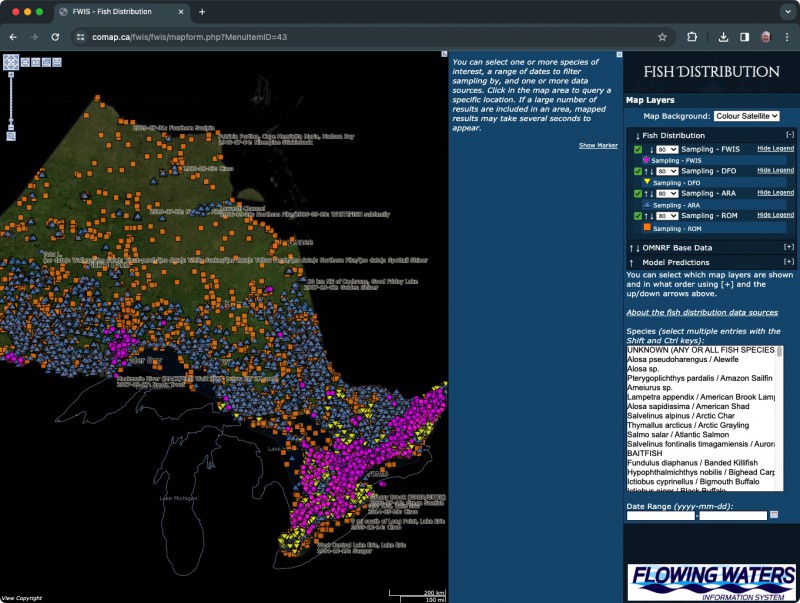
This image is a screen capture of the FWIS Fish Species Distribution mapping. To access this system, Login/Register and locate the Fish Species Distribution link in the Data Summaries and Queries drop-down menu. To try out the map, select one or more species of interest, a range of dates to filter sampling by and one or more data sources. Click in the map area to query a specific location.
The availability of a common information system accessible to all stream surveyors reduces costs, increase communication and data sharing, increase sample sizes and power of statistical tests on the effects of regulations, habitat improvements or other management techniques, and permit comparisons to be made across spatial and temporal scales. Moreover, a common information management system accessible to all stream surveyors through the internet provides a venue to facilitate development of a community of practice on Great Lakes stream fisheries management. The availability of a collective data set that can readily be compiled from a web-enabled information management system will support predictive modeling.
|