Socio-economic Indicators for Causes and Consequences of Land Degradation
Lisa Svensson
1. Introduction
The purpose of this paper is to investigate relevant socio-economic indicators that can be utilized within the Land Degradation Assessment in Drylands (LADA) project. This investigation attempts to identify and assess these indicators based on a two stage process. First, documented linkages between socio-economic factors and degradation outcomes are reviewed to attempt to identify those factors that have been observed to be linked to degradation in drylands. Second, the availability of data sets at a global, national, or local scale to represent these identified socio-economic factors is evaluated, so as propose preliminary indicators.
The purpose of an indicator is to provide information about a condition, or monitor and evaluate if a certain objective has been achieved. Indicators can measure inputs, processes, outputs, and outcomes (Horsch, 2005). Desirable attributes of an indicator are that they should have user relevance, be measurable, and have a clear relationship between the object and, or the process, that is being evaluated.
Several issues need to be addressed in this exercise. First, the object being evaluated (land degradation) must be defined, if the indicators are intended to be clearly related to this factor. This requires exploration of how land degradation is defined in the LADA project and definition of the subprocesses that are encompassed within this definition. The second issue is to understand the direct processes that lead to the identified land degradation and its impacts, in doing so the underlying causes, or drivers, can thereafter be analyzed. Finally, the types of data that are available must be identified.
Accordingly, the paper will start with exploring the definition and types of land degradation, and the direct and indirect processes leading to land degradation. Thereafter, some documented socio-economic factors will be summarized and discussed. The subsequent chapter will first review some existing indicator sets for land degradation and then the results from data search are presented. Finally, a recommended list of socio-economic indicators is offered together with a discussion of the findings explored in the paper.
2. Land Degradation in Drylands
Land degradation in drylands is a very complex process, which is not a single factor outcome, but is rather an emergent property of interacting human and biophysical factors. Even though the concept of land degradation in the drylands has been discussed for more than 30 years, there is little consensus about how it arises (for an overview, see for example Prince (2002) and Dregne (2002)).
The land definition utilized in the LADA project is as follows. Land refers to the terrestrial surface, which includes all attributes immediately above and below the surface. These attributes include; the near surface climate, soil and terrain, surface hydrology, the near surface sedimentary layers and associated ground water reserve, plant and animal population, and, also, human settlement and physical results of past and present human activities. (FAO)
Furthermore, land degradation is a process and it occurs when one process, or a combination of processes, cause a reduction of the potential productivity of land resources (UNEP, 1992). The processes comprise water and wind erosion, sedimentation caused by eroded soil, long-term reduction in the amount or diversity of natural vegetation relevant, and salinization and sodification. The land can be diagnosed as degraded, caused by natural processes or human activities, when it is no longer able to adequately sustain an economic function and/or the original function (ISO, 1996).
In the context of drylands, degradation is closely related to desertification. According to the United Nations Environmental Program (UNEP) the definition of desertification is land degradation in arid, semi-arid, and dry sub-humid areas that are caused by human and climatic factors.
The temporal scale in the definitions above is not explicitly defined. Fernadez et al. (2002) suggest that land degradation takes place when the biological productivity decreases under current management, which will diminish productivity in the foreseeable future, and the processes are not reversible with resources that are available to the decision maker. Moreover, desertification will occur when land restoration is no longer possible within a temporal scale that is relevant to humans. Prince (2002), on the other hand makes a distinction between land degradation and desertification. Land degradation takes place, according to Prince (2002), when the disturbing elements are removed, for instance when rainfall return after a drought, and the community recovers, while desertification is irreversible or slowly reversible conditions of the land.
Causes of land degradation can be divided into proximate causes and root causes or underlying driving forces, as illustrated in figure 1. The proximate causes are those factors that directly affect the land, which is the land management of agricultural activities, infrastructure, harvesting of wood products, and draughts and fires, whereas indirect drivers constitute demographic, economic, technological, political/institutional, and cultural factors.
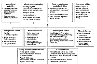
Figure 1. Proximate causes and underlying drivers for land degradation, where the first row constitute four broad clusters of the former category and the following row representing six broad groups of root causes. Source: Geist, H., and Lambin, E. 2004
In order to be able to understand the linkages between the proximate, the underlying causes and land degradation, the degradation outcome, or type, must first be evaluated and the processes that cause the specific type of degradation should be identified. The proximate causes can thereafter be identified for these processes. The third step includes discovery of the underlying causes. Typically, socio-political-cultural-economical factors that influence the land use practises of the proximate causes fall within these underlying causes. Furthermore, there is often a feedback loop from the degradation outcome. Will the land practices change when there is sign of unsustainable land use or will the problems simply continue to grow in both size and severity? Thus, the result from degradation will influence the environmental services that in turn will influence the population, but the effect on, and the responses from the society depends again on all the above stated factors. Which are the factors that trigger the feedback loop? Understanding the linkages is central and therefore it might be useful to set up hypothesis between natural and socioeconomic “indicators” on the one hand and various degradations on the other.
However, assessing and measuring land degradation is far from trivial. For instance, what is the net effect of soil erosion and for whom is the land degraded? Reynolds et al. (2003) highlights these types of questions in the following example. If a large number of erosion guiles are found in an open rangeland with grazing cattle, it is logical to think that these guiles are caused by overgrazing, and that these guiles will affect the vegetation cover, cause soil erosion and reduce the beef productivity. While this might very well be true there are also a number of other causes and consequences that can explain the guiles. For example, some erosion guiles are naturally caused by wind and water, and the guiles, natural or human induced, might not have any effect on the beef production, but the guiles can cause down stream effects. Furthermore, even if the guiles are caused by overgrazing the underlying causes might be overstocking by the ranch manager, insecure land tenure system or broader institutional/political problems, or largely natural processes linked to regional or global change, or indeed a combination of all these underlying causes. Therefore, guiles or number of cattle do not per se represent land degradation and, thus, degradation should be viewed in a greater context that includes socio-economic factors. Nevertheless, socio-economic factors are principally underlying causes, and cannot be used in isolation to appraise much about degradation outcomes. Rather, the intermediate interlinkages of proximate causes are needed to link socio-economic factors to different forms of degradation. Thus, while socio-economic information is critical to the understanding of why degradation occurs, analysis of such information must be integrated with the analysis of biophysical factors.
Moreover, different parts of a landscape are more or less prone to degradation, and therefore some segments of a study area might be degraded while other parts are not, due to three reasons. First, the land around water holes might be degraded because of over utilization from crop production and grazing while further remote areas like woodlands might be less affected. The second reason is due to the fact that soil properties, like texture, micro-topography, and drainage patterns, may vary substantially. The third reason is that rainfall varies within an area especially in semi-arid areas. (Prince, 2002)
The climate and temporal factors must be taken into consideration when assessing land degradation as, for example, with a lasting draught land management practices may become non-sustainable and the only solution might be to remove or decrease the production that is taking place (Prince, 2002).
3. Documented Socio-economic Factors
Geist and Lambin’s (2004) results from a meta-analysis, including 132 case studies from all over the world, show that agricultural management or agrarian land uses are the proximate causes associated with desertification in 95 percent of the case studies. Consequently, an analysis of socio-economic drivers that influence farmers and, thus, their land management practices, the proximate causes, seems relevant. The following socio-economic drivers, or underlying causes, were isolated, in order of degradation-relevance: population pressure, poverty, labour availability, input availability, road access, and education.
Yet, these factors are only a part of all factors that determine farmers’ choice of land management practices. As depicted in figure 2 (Shiferaw and Holden 1998) an array of interlinked factors will determine the farmer’s choice of production methods. The extent of land degradation depends thus on a complex interaction of a number of factors, which are very site specific. Farmers’ decision on conservation practices depend on their perception of the cost and benefits associated with them (Wiebe, 2003). These incentives or disincentives will vary from farm to farm, and from time to time. And as the short summary of some factors below show investigating the same factor will have different consequences in different locations, due to the fact that so many factors influence the farmer. There are many management practices that can be considered as land conservation investments because they maintain soil fertility or reduce soil erosion, nutrient and pesticide runoffs (Wiebe, 2003). Conservation practices include for example conservation tillage, contour farming, buffer strips along watercourses, terracing, and soil fertility inputs.
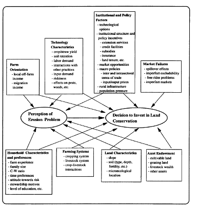
Figure 2. Factors that determine farmers’ decisions. Source: Shiferaw and Holden, 1998.
Population pressure
There are several hypotheses about population growth and resource degradation. Boserup argues in her classic work (1965) that rural population density is a requisite for agricultural intensification, which lead to increase in yields and increase in outputs per capita. The theory behind it is that as population increase, land becomes scarce and less land can be laid in fallow, which means that agricultural techniques must change. Boserup (1981) expands her theory to include soil erosion. Population growth reduces the land/labour ratio, which make land scarcer while labour supply increases leading to lower wages and higher land prices. New institutions such as private property rights will emerge. Food demand will increase, which will change the relative prices of agricultural outputs. Altogether this will generate greater investments that improve the land, such as fertilizer application, conservation infrastructure (e.g. terracing), and plantation of perennials.
Tiffen et al. (1994) give support to the theory of Boserup, through their study of the semi-arid and hilly Machakos district in Kenya. The authors show that despite, or because of, nearly a six time population increase between 1932 and 1989, agricultural productivity increased and land degradation halted as a result of adoption of new conservation techniques. It is also acknowledged by the authors that additional preconditions are necessary for a positive relation between high population growth, resource conservation, and agricultural productivity increase. These preconditions include; peace, security for trade and investments, and secure tenure systems. However, it is not clear how many of the positive developments were due to the opening of land access for all users, investments in infrastructure, access to non-farm opportunities, technological developments that were brought from outside, price incentives for specific crops Markandya (2001), or how big a role the district’s closeness to the capital played.
Along with Boserup’s population growth theory, is the induced innovation hypothesis, which states that as population grow and markets expand, the value of land will increase and adoption of new technologies is necessary (Ruttan and Hayami, 1990).
Barbier (1998) gives support to both Boserup’s theory and the induced innovation theory. Results from a bioeconomic model in a village in a sub-humid West Africa show that population increase lead to agricultural intensification and land conservation techniques. But this might not necessarily mean higher incomes for farmers. Therefore it could be better to let farmers migrate from high population density areas to low population areas, as under current economic conditions, found in most Sahelian countries, it is more expensive per hectare with agricultural intensification than applying extensive agricultural practices (Barbier, 1998).
Grepperud (1996) on the other hand finds in the Ethiopian Highlands that population pressure lead to land degradation. The author gives support to the population pressure hypothesis (PPH) (Blaikie and Brokfield, 1987), and his results show that severe and rapid soil erosion take place if pressure from population and livestock exceeds the carrying capacity of the land. However, if population and livestock densities are far below the threshold, population growth could rather act as an incentive for resource conservation practices (Grepperud, 1996).
Southgate et al. (1990), investigate causes of land degradation in South America and Africa and their conclusions are that the principal response in these two continents to demographic and market shocks is extensive agriculture production on fragile lands rather than intensified production.
Land Tenure
Poorly defined property rights may lead to resource degradation, as individual investments in maintenance and enhancement can be captured by others (Hardin, 1968). Furthermore, farmers’ decision on land conservation practices is indeed subjected to a temporal dimension (Wiebe, 2003). Several conservation practises, such as terracing, have a long lags between investments and returns, and therefore the type of land tenure system is indeed an important factor. Bromeley (1990) group natural management property regimes in into three general classes: (a) state property regimes, (b) common property regimes, and (c) individual property regimes. In the two latter classes, the mangers or users are also the owners, while the managers or users are not the owners in state property regimes such as national forests. It is important not to mix open-access regimes with common property regimes, as in the former no property regime exists. In many developing countries state property rights are frequent with no control over individual user behaviour leading to open-access regimes and natural resource management by proclamation, which does not work (Bromely, 1990).
Empirical evidence of the open-access regime can be found in the Sahel in West Africa where land conservation practices are highly discourage as farmers can only temporarily use parcels under the current communal tenure regimes (Southgate et al. 1990). Planting of perennials and trees are therefore considered to be a declaration of individual rights, and, thus, crops that could harness soil erosion are not planted. De Janvry and Garcia (1988) explain the low investments in conservation practices by poor farmers in South America with insecure land tenure regimes. In contrast, Deininger and Minten (1990), found that communal lands in Mexico, with institutions providing security and conditions for collective actions, did not generate higher rates of deforestation.
Better institutions with property rights can be induced by population increase, but the rate at which the population grows may also be a factor in property rights. Slow population growth rates have time to establish common property systems or private property regimes from open-access recourses (Paarlberg, 1994). Rapid population growth may on the contrary lead to the breakdown of traditional systems with well functioning common property systems into open-access with associated land degradation (Cuffaro, 1997).
Poverty and resource degradation
The “poverty trap” or “downward spiral” theory suggests that poor people, as they live from hand to mouth, cannot afford to invest in resource conserving practices so instead they continue to plough up hillsides and overgraze land as they cannot wait for rangelands to recover (Parlberg, 1994). Thus, these practices will lead to increased land degradation and worsen poverty. However, this topic is frequently debated (Markandya 2001, Scherr, 2000).
Deninger and Mintzen (1996) show a negative correlation between poverty and plots being under forest cover in Chiapas and Oaxaca regions in Mexico. The higher the incidence of poverty the lower likelihood of tree-cover. However, the “downward spiral” is challenged by Forsyth et al. (1998) who say that poor communities implement land use controls to stabilize vegetation cover. Moreover, the use of indigenous techniques control degradation and farmers ability to diversify activities for halting land degradation while maintain income. Also Markadya (2001) challenges the “poverty trap” when he concludes in a literature review that poverty does not damage the environment, but it is rather an array of policies that are to be blamed. Similar conclusions are drawn by De Janvry and Garcia (1988) from South America where subsidies for agricultural inputs such as fertilizer, pesticides, and mechanization equipments do not reach the poor, and that the poor are facing insecure land tenure systems. These conclusions are also confirmed by results from Colombia by Heath and Binswanger (1996). Southgate et al. (1990) also point out that price distorting effects of low food prices that benefit the urban population, and price instability motivates farmers to practice extensive farming rather than agricultural intensification.
Shiferaw and Holden (1998) show from a case study in the Ethiopian Highlands that in the absence of appropriate policies and technological assistance, and at the same time with an increasing population, rural poor households can be caught in a poverty – population – environment trap that may be triggered and lead to increased poverty and land degradation.
Labour availability
Off-farm employment opportunities may help to alleviate pressure on production resources. In Rwanda farmers invested more in conservation infrastructure as non-farm income and livestock earnings increased (Clay et al. 1995). The same phenomenon was also found in the Machakos district in Kenya where farmers’ invested their off-farm derived income in paid labor to maintain terraces (Tiffen et al. 1994). Furthermore, in a survey from Uganda it was also found that non-farm activities or livestock production gave lower soil nutrient depletion due to higher incomes (IFPRI, 2004).
However, in many places of Africa shortage of rural labour has lead to abandon of traditional resource conservation practices such as terrace maintenance (Paarlberg, 1994). Warren et al (2001) show from a village in Southwest Nigeria that soil erosion increases with seasonal male labour migration as less labour is available for soil conservation practices.
Job opportunities outside the farm may not be the only cause of reduced labour availability. Prevalence of HIV/AIDS has a great impact on rural poor and agricultural practices (Gillespie and Kadiyala, 2005). HIV/AIDS reduces labour supply due to both morbidity and mortality and affected household have to suffer from both increased costs (health-care expenses and funeral costs) and loss of labour input, both on-farm and off-farm earnings, and agricultural knowledge.
Input availability and road access
Unavailability or high prices for key agricultural inputs, such as fertilizers, may render it unprofitable to preserve soil nutrient levels. In many developing countries, especially in Sub-Saharan Africa, nutrient depletion is becoming a major problem as nutrient removal exceeds nutrient replenishment (Bumb and Baanante, 1996). If proper amounts of nutrients, organic and inorganic, are not applied then crop production cannot be maintain and would thus lead to soil degradation. Therefore, one important issue to investigate when assessing land degradation is to measure the amount of fertilizer usage.
From 107 communities in Uganda it was observed that households with higher incomes had lower soil nutrient depletion as these households did invest in fertilizer and manure (Pender et al. 2004). Results from Uganda shows that households with poor access to roads use less organic and inorganic fertilizer (Nkonya, et al., 2004).
Input prices of fuel may also affect land management practices as low prices for diesel may make excessive tillage in mechanized systems attractive. In Indo-Gangetic Plains, India, the adoption of zero-tillage practices was expanded after that the price on diesel was increased (Vincent and Quirke, 2002).
Fan (2004) shows the importance of investment rural road infrastructure as a pro-poor strategy. Building on results from country studies in China, India, and Uganda, it is demonstrated that roads reduces poverty as they facilitates off-farm work and access to education and increases possibility to sell agricultural. Higher income may be invested in land conservation, but as illustrated before this is not necessarily always the case and reduced labour availability might lead to increased land degradation.
However, in Eastern Uganda farmers with access to roads and markets had high levels of soil nutrient losses. The farmers did not invest in additional fertilizer usage, or any other soil fertility practices, as to replace nutrients due to produce selling at markets (Pender et al., 2004).
Education
Education may affect natural resource management several ways. First, investing in human capital is one of the keys in reducing poverty (the World Bank 1990) and as previously discussed, poverty may have indirect linkages to land conservation practices. Secondly, educated farmers are more likely to adopt new technologies and numerous studies show that farmers with education have higher returns from their land (the World Bank, 1990). Also, higher education may provide off-farm labour opportunities, which again can have several implications in agricultural practices.
Improved land management practices due to education were observed in Uganda. Households with education had in general higher incomes and they were inclined to have vegetable production and high fertilizer usage leading to less erosion and lower nutrient depletion (Pender et al. 2004).
4. Data Availability
Collection of socio-economic data varies significantly over the world in quality, frequency, and methods and compilation. Many institutions like the World Bank, the United Nations and its specialized agencies, do compile statistics from national governments and they make those figures available under various themes. Additionally, these agencies generate estimates and forecasts of numerous indicators. However, these data are only, in most cases, available on national scales and sub-national data must be obtained directly from individual countries, which in some cases is easily accessible on the internet, but more often only data on national scale, if any, are available immediately. Thus, to collect socio-economic indicators for a large number of countries is a considerable task, as it would be necessary to contact each country’s statistical agency and/or specialized bureau in the country responsible for collecting particular data. Furthermore, it also requires an understanding about individual data sets for making indicators comparable over different countries.
In this section, a few short reviews of selected initiatives on socio-economic indicators and land degradation are presented. Thereafter, a number of data sources are evaluated regarding their supply of sub-national data sets. A table that summarizes the findings is found in the end of the chapter.
Desertlinks, MODALUS and MEDACTION
The European Commission has through their Framework Programme 5 founded several programmes concerning desertification, including Desertlinks and MEDACTION. By involving scientists and stakeholders in the project, Desertlinks has produced a database with indicators intended for local stakeholders for evaluation of alternative management options and for national committees for monitoring land degradation or desertification in the European Mediterranean area. Desertlinks’ indicator database is extensive and it comprises both biophysical and socio-economical indicators. Each indicator is described with seven headings, including a short description of the indicator, the indicator’s position within the D.P.S.I.R framework, the indicator relevance, the approach to use with the indicator, and data sources and data availability.
Some of the socio-economic indicators that can be found in the project’s database include:
Level of adult education, depopulation caused by degradation of the natural resources, employment rate, production subsidies, expenditure on water, age of farmers, farm ownership and farm size, fertilizer application, number of parcels per holdings, gross domestic products (GDP) per capita, human poverty index, livestock intensity, local Agenda 21, mechanisation index, net farm income, old age index, parallel employment, population density and growth, protected areas, research and development expenditure, various measurements of tourism, unemployment rate, value added of workers from different sectors, and water consumption by sector.
Many of these indicators are indeed relevant for the LADA project. However, data at a global scale for several of these are not available, but may indeed be readily accessible for some of the LADA pilot countries at district level, or perhaps collected at village level in individual case studies. Furthermore, data sources for several of the indicators referred to in Desertlink’s data base include the World Bank and the United Nations, and these agencies, as is explained below, only possess country level statistics. Other data references are directly to national statistical agencies.
Mediterranean Desertification and Land Use (MODALUS) was a project carried out between 1990 and 1999. In their project report from 1999 entitled; The MEDALUS project Mediterranean desertification and land use - Manual on key indicators of desertification and mapping environmentally sensitive areas to desertification, no socio-economic indicators are considered.
MEDACTION is a multi disciplinary research project that study land use policies for combating desertification, and they build their research mainly on results form the MODALUS project. One of MEDACTION’s deliverables is a paper entitled Factors Sectors Actors and Indicators in which a list with important indicators are presented. The list includes for example: population density, migration, education, crime rate, mortality rate, subsidies, unemployment rate, prices, number of rich people, and tourism can be found. Data sources and availability for these are, however, not discussed.
LADA Database
A database was created with various indicators regarding land degradation. The indicators are categorized within the Sustainable Livelihoods Framework using its five capitals; Social, Physical, Financial, Human, and Natural. However, it is also possible to enter various indicators by choosing theme, sub-theme, spatial scale (global, national, or local), or via the D.P.S.I.R. framework. Contingent on which category is chosen a set of indicators will be displayed in the indicator section from which the user then can select an indicator. This information is then displayed on a report sheet. These sheets, when data has been entered, will contain a great number of information that is linked to the indicator being considered. Information for the most part is at the moment lacking, so it is hard to evaluate the usefulness and value of the database. However, the added value of categorization via the capitals in the database is not really clear, at least if the objective is to investigate the causes or consequences of land degradation.
Application of an Ecosystem Approach to Degradation Assessment of Drylands in Argentina
This LADA pilot study was carried out jointly by the LADA Taskforce for Argentina and World Resource Institute, in 2003. In this study four dryland areas in Argentina are described. Applying an ecosystem approach, each area is described in terms of four ecosystem services, drivers of change, and indicators of human well-being. However, linkages between land degradation and the four categories of ecosystem services, and human well-being indicators are not apparent in this analysis
Data Sources
Statistical Division of the United Nations, http://unstats.un.org/unsd/
The statistical division of the UN provide national data that the organization request and compile directly from individual countries. The data collected include a number of topics; social and demography, energy, the environment, national accounts, trade, and the millennium goals with various targets and indicators related to the goals. One section of the division’s webpage is entitled Social Indicators, which holds a list of indicators. The list comprises indicators such as child bearing, education, health, housing, human settlements, illiteracy, income and economic activity, population, employment, water supply and sanitation, youth and elderly populations. However all of these indicators are solely available at a national level.
Thus, the statistical division provide only national data and the division assemble the country data with various methods. For example, the Population Division of the UN secretariat calculate the number of people in each country based on projections and estimates every two years. Educational level data is collected through the United Nations Educational, Scientific and Cultural Organization (UNESCO) that acquires the data by questionnaires to national governments.
Furthermore, every ten years the statistical division facilitate member countries with guidelines and recommendations with methodologies to conduct population and household censuses. On their website http://unstats.un.org/unsd/demographic/sources/census/ all population and household censuses that have been carried out in the world since the 1970s are listed. In all the six LADA pilot countries, population and household censuses have been conducted with variation in frequency as depicted in table 1.
Table 1 LADA pilot countries’ population and household censuses
| Country |
Year(s) |
|
Argentina |
1991, 2001 |
|
China |
1990, 2000 |
|
Cuba |
2002 |
|
Senegal |
1988, 2002 |
|
South Africa |
1985, 1991 1996, 2001 |
|
Tunisia |
1994, 2004 |
Source: the United Nations Statistics Division
The list of topics the division provide in their recommendations for population and household censuses contains for example queries regarding geographic and internal migration, household and family characteristics, educational description, fertility and mortality, economical issues, type of house, and tenure contract. For sub-national data each country must be contacted, or some in some cases detailed data is published on national websites. Nonetheless, it is very valuable to know if any census has taken place to understand which data expect in different countries.
Food and Agriculture Organization of the United Nations (FAO)
FAO collects data provided by countries and agencies regarding agricultural issues and these statistics are published in the FAO statistical yearbook, which also includes estimations and forecasting. The organization has also established several initiatives to map out available data on sub-national levels. In the following sections some of these initiatives, and regular statistical work that the Organization carries out, are shortly described.
Economic and Social Department, Statistics division ESS, www.fao.org/es/ess
The Statistics Division of FAO puts together an array of demographic and agricultural data from 185 countries, which for example results in the FAO Statistical Yearbook. However, all data are reported on a national level only. The service assembles socio-economic data for the whole world, but only national data are available. About 20 years ago, a global collection of population and crops on district level/AEZs was compiled after three years of effort. Presently, due to financial constraints, ESSA does not record data on finer spatial scale than national levels (Cerri, 2005. per. comm.)
Table 2 Agricultural census surveys conducted in the pilot countries of LADA
| Country |
Agricultural Census |
Year(s) |
|
Argentina |
Farm size, legal status of the holder (civil persons, corporation, cooperative, government), land tenure of the holdings (owned, rented), number of household members (male, female), farm population by age, employment in agriculture (householder members engaged in agricultural work at the farm), machineries, information on land use and number of livestock |
1988, 2002 |
|
China |
Farm size, household members, legal status of the holding (civil persons, corporation, cooperative, government, other), household members of the farm who are mainly engaged in agricultural work, hired permanent workers, and crops and livestock. |
1997 |
|
Senegal |
Size of cultivated land, household members engaged in agricultural work on the holding, hired permanent and temporary workers, household members, holders by age and sex, and livestock and crop information |
1998-99 |
|
South Africa |
No summary of main findings at FAO website. Census 2002 was conducted on commercial agricultural holdings only. |
1993, 2002 |
|
Tunisia |
No summary of main findings at FAO website. |
1994-95, & 2004 |
Source: Economic and Social Department, Statistics division ESS of FAO
Moreover, the Division guides member countries on how to conduct agricultural census surveys, and they provide statistics on their website, which is updated every 3-4 months (Srivastava, pers. comm.). On this webpage information about when the various countries carry out agricultural censuses can be found. For some of the results the division has made short summaries of the census surveys’ main findings and can be found at the following site; www.fao.org/es/ess/census/wcares/default.asp
Table 2 depicts the agricultural census surveys undertaken by the LADA pilot countries and, when available, a short description of the contents of the surveys. All data come from the website provided earlier.
Economic and Social Department, Nutrition division (ESN), www.fao.org/es/ESN
The ESN Division has created country profiles for 58 countries with information about nutrition intake and various health indicators of food consumption on first level boundaries. With 11 countries in Africa, 14 countries in Asia and Southwest Pacific, 28 countries in Latin America and the Caribbean, and five countries in the near east, the country profiles include various numbers of indicators, which are spatially distributed in various degrees for the individual countries. Indicators includes energy intake, underweight among children, prevalence for stunting (height for age) and wasting (weight for height), prevalence among adults with body mass index (BMI) below 18.5 kg/m2, and vitamin A deficiency among children. For each country there is a country report including administrative maps showing the data provided spatially.
China, Cuba and Argentina are the only LADA pilot countries that are represented in this country profile studies, although data for Cuba are mostly aggregated at national level. The country reports were conducted 1999 utilizing data from various years prior to the composition.
Sustainable Development Department, Research and Technology division (SDRN), www.fao.org
The Division has recently produced administrative maps for 273 countries on first level boundaries and for about 225 countries boundaries at the second level. Also, the division has data available on population densities at 1km2 scale and these figures could be combined with the administrative boarders. The most reliable population data are from 2000 (Ataman, 2005, pers comm.), but data for 1990 and 1995, and projection for 2015 exist also. Access to roads is also available at 1km2 spatial scale. Sub-national data on protected areas exists, but the data must be organized before it is possible to present at finer scale (Marinella, pers. com.).
For many countries the Division has also produced poverty maps for malnourished children below five years of age depicting prevalence of stunted, using nutrition surveys conducted between 1987 and 2002. Regarding many countries, or parts of counties, these figures are available at sub-national levels. Eventually the Division plans to create sub-national maps illustrating the usage of wood-fuel (Ataman, 2005, pers. comm.).
Food Insecurity and Vulnerability Information Mapping Systems (FIVIMS), www.fivims.net
This inter-agency programme is collecting spatial data from various sources for mapping food insecurity and vulnerability around the world. For the following 16 countries maps have been produced on poverty prevalence, utilizing data from different years and sources. Argentina, Belize, Chile, Colombia, Ecuador, Venezuela, Peru, Paraguay, Panama, Nicaragua, Mexico, Vietnam, Philippines, rural India, Uganda, and Senegal, and in addition to the two African countries poverty incidence for the Sahel area is also recorded. Several of these maps were first published in “The state of food insecurity in the world FAO 1999”. These maps are linked to the website of GeoNetwork, hosted by FAO.
GeoNetwork www.fao.org/geonetwork/srv/en/main.search
GeoNetwork is an internet based tool that allows different FAO Units, other UN Agencies, NGO's and other institution, to share geographically referenced thematic information. On GeoNetwork livestock densities for the entire world (Europe will be finalized later) spatially distributed at 3minarc (5km) (Robinson, 2005, pers. comm.) For most areas the density of cattle, pigs, chickens, sheep and goats are accessible.
Global Livestock Production and Health Atlas (GLiPHA), Animal Production and Health Division, www.fao.org/ag/aga/glipha/index.jsp
The website provides maps, tables, charts and metadata, on data related to animal production around the world. Four themes can be selected; Biophysical (land), Socio-economics (demographic, food supply, and agriculture production index), livestock population and production (density, growth rate etc), livestock health, and livestock trade. While much of the data can be found at regional levels, sub-national data is accessible for 23 countries of which three LADA pilot countries are included; Argentina, China, and South Africa.
Pro-Poor Livestock Policy Initiative (PPLPI), Animal Production and Health Division FAO, www.fao.org/ag/againfo/projects/en/pplpi/resources.html
This project aims to reduce poverty through formulation of international and national livestock policies. The website provides some maps about poverty prevalence, livestock density etc, but everything at national levels.
Global Information and Early Warning Systems; on food and agriculture (GIEWS), www.fao.org/giews
This website provides information on 46 countries in Africa on their agriculture situation and population. Population density is in most cases depicted at administration level, but additional demographic data is only available at country level. Food balance, supply and utilization, is also only reported at national levels. However, administrative maps are provided for the countries. Only satellite pictures of Latin America and the Caribbean are available and nothing is reported on the Asian countries.
FAO Country profiles and Mapping Information Systems, www.fao.org/countryprofiles
This site offers maps for many countries with bio-geophysical indicators, types of farming systems and population distribution at fine spatial scale. Administrative boundaries are also provided. However, no other socio-economic indicators are presented by the site.
World Health Organization (WHO), www.who.int
The WHO has a website entitled the Health Mapper, which is a GIS based programme and it includes 60 countries around the world for monitoring infectious diseases. These maps also include basic information like health information, educational facilities, accessibility by road, access to safe water, and demography. However, few details are provided, so more investigation is required for understanding the level of information depicted in the maps, and also for which countries data is accessible.
Furthermore, WHO has country profiles about demography, access to services, morbidity and mortality indicators, and other socio-economic indicators, which are all presented at national levels. For sub-national data, the WHO headquarters recommend to directly contact their regional offices, which in general have more detailed data (Duppenthaler, 2005. per. comm.).
Untied Nations Development Program (UNDP), Human Development Reports, http://hdr.undp.org/statistics/
The UNDP publish annually, since 1990, the Human Development Report, which is a report that monitor peoples well-being in 177 countries judged on, when available, 33 different indicators. All data is however only available at national level.
United Nations Educational Scientific and Cultural Organization (UNESCO) Institute for Statistics (UIS), www.uis.unesco.org
The Institute for Statistics of UNESCO collect data from national authorities in more than 150 countries. The statistics include education, literacy, culture and communication, and science and technology. These data sets, which show national data, are presented in tables, databases, and country profiles.
World Resource Institute (WRI), www.wri.org
One of the World Resource Institute (WRI) objectives is to increase availability of information about the conditions of the World’s ecosystems. Data about population and environmental issues from various sources are therefore compiled and accessible on the WRI’s webpage. Significant amount of data and indicators are to be found under Earth Trends – The Environmental Portal with ten different categories (for example various ecosystems, energy, climate issues, agriculture and food), and one category entitled Population, Health and Human Well Being, which includes demographic indicators, education and literacy, population, health and human well being, and trends in mortality and life expectancy with statistics for more than 150 countries. For all these sub-categories many indicators are included, but everything is reported for country levels and a few of the indicators are divided into urban-rural figures.
Moreover, the Earth Trend section on the same website provides poverty maps for 25 African countries, 16 countries in Asia and the Middle East, and 12 countries in South America and the Caribbean. In tables 3, 4 and 5 the different types of poverty measures are depicted with five categories; underweight children, incidence of poverty, incidence of rural poverty, poverty head count index, and human development index. The three tables show all the countries and which year the type, or types, of poverty surveys were conducted.
Table 3, which shows the African countries, depicts that 13 countries have conducted surveys for measuring the percentage of children who are underweight. Thirteen countries have also measured the incidence of poverty, of which four countries have measured rural poverty. While poverty headcount index and human development index is only measured in four countries respectively.
Table 3 Type of poverty measurement year of survey in Africa
|
Country |
Poverty Measure | ||||
|
Percent of Children Underweight |
Incidence of Poverty |
Incidence of Rural Poverty |
Poverty Head Count Index |
Human Development Index | |
|
Benin |
2001 |
||||
|
Burundi |
1997 |
||||
|
Cameroon |
1996 |
||||
| Cot d’Ivore |
Year not available |
||||
|
Egypt |
2000 |
2000 |
2000 | ||
|
Gambia |
1998 |
||||
|
Ghana |
1998 |
1999 |
|||
|
Guinea |
1999 |
||||
|
Kenya |
1997 |
||||
|
Lesotho |
1993 |
||||
|
Madagascar |
1999 |
||||
|
Malawi |
2000 |
1998 |
|||
|
Morocco |
1992 |
||||
|
Mozambique |
1997 |
1999 | |||
|
Namibia |
2000 |
||||
|
Niger |
1993 |
||||
|
Nigeria |
1996 |
1993 | |||
|
Rwanda |
1993 |
||||
|
Senegal |
1992 |
||||
|
Sierra Leone |
1990 |
1998 | |||
|
South Africa |
1995 |
1993 |
|||
|
Swaziland |
1995 |
||||
|
Tanzania |
1996 |
||||
|
Togo |
1998 |
||||
|
Zambia |
2000-01 |
1998 |
|||
Source: The World Resource Institute; Earth Trends
Table 4 presents the countries in Asia and the Middle East. Of the 13 countries that are represented, nine countries have measured the prevalence of underweight children, while seven countries have surveyed the incidence of poverty for which one country shows rural poverty. Headcount index and human development is again measured in four countries, respectively.
Table 4 Type of poverty measure and year of survey in Asia and the Middle East
|
Country |
Poverty Measure | ||||
|
Percent of Children Underweight |
Incidence of Poverty |
Incidence of Rural Poverty |
Poverty Head Count Index |
Human Development Index | |
|
Bangladesh |
2000 |
||||
|
China |
1996 |
1997 | |||
|
India |
1998-99 |
2000 |
2000 | ||
|
Indonesia |
1999 |
||||
|
Iran |
1996 | ||||
|
Jordan |
1997 |
1997 |
|||
|
Kazakhstan |
1999 |
1996 |
|||
|
Kyrgyzstan |
1997 |
2001 |
|||
|
Lao, Peoples Republic |
1998 |
||||
|
Lebanon |
2002 |
||||
|
Nepal |
2001 |
||||
|
Pakistan |
1990-91 |
1999 |
|||
|
Russian Federation |
2000 | ||||
|
Tajikistan |
1999 |
||||
|
Uzbekistan |
1996 |
2001 |
|||
|
Yemen |
1991-92 |
1998 |
|||
Source: The World Resource Institute; Earth Trends
Countries in Asia and the Caribbean are represented in table 5, which shows that eight of the 12 countries have conducted surveys for measuring the percentage of children who are underweight. Five countries have measured the incidence of poverty including two countries that measured rural poverty, while two countries have carried out poverty headcount index, and one country has conducted a human development index.
Table 5 Poverty measurement and year of survey in South America and the Caribbean
|
Country |
Poverty Measure | ||||
|
Percent of Children Underweight |
Incidence of Poverty |
Incidence of Rural Poverty |
Poverty Head Count Index |
Human Development Index | |
|
Bolivia |
1998 |
||||
|
Brazil |
1996 |
1996 |
|||
|
Colombia |
1999 | ||||
|
Dominican Republic |
1996 |
||||
|
Ecuador |
2001 |
||||
|
El Salvador |
2001 |
||||
|
Guatemala |
1995 |
2000 |
|||
|
Haiti |
2000 |
1996 |
|||
|
Honduras |
1998 |
||||
|
Mexico |
2002 |
||||
|
Nicaragua |
1993 |
||||
|
Peru |
2000 |
||||
Source: The World Resource Institute; Earth Trends
Centre for International Earth Science Information Network CIESIN, www.ciesin.org
CIESIN is a centre within the Columbia University with the mission to provide accessible worldwide information regarding both biophysical and socio-economic data, as to understand human interaction with the environment. The centre provides information on the global population on sub-national levels. Data on maps include population densities and administrative boundaries with estimations calculated for three years, 1990, 1995, and 2000. Furthermore, maps containing significant amount of socio-economic data can be found for Mexico and China.
The World Bank, www.worldbank.org
The World Bank collects considerable quantities of data from national governments. Most of the data are only accessible on aggregated national levels. The Bank has a webpage about poverty, PovertyNet, www.worldbank.org/poverty/ and in its data section; Data and Tools, the page provides information on type of data sources and surveys the bank is utilizing.
Development Data Platform (DDP) provides information on when and what kind of surveys that various countries have conducted. To the public, the Bank offers Excel spreadsheets, prepared in August 2004, that encompass contact details to individual countries for further information.
The Living Standard Measurement Survey (LSMS) website, with the address: www.worldbank.org/lsms/, shows when various LSMSs were conducted, but access to the data is again only accessible via national authorities. Program for the improvement of Surveys and the Measurement of Living conditions in Latin America and the Caribbean is an initiative that aims to improve data quality and to make the data more accessible. Currently eight countries are participating; Argentina, Bolivia, Dominican Republic, Ecuador, El Salvador, Guatemala, Honduras, Nicaragua, Paraguay, and Peru. A link is provided to the Demographic and Health Surveys (DHS), which includes information on when and where DHS were conducted.
The African Household Survey Databank is a searchable engine and it holds information about surveys and censuses conducted in Sub-Saharan Africa. In addition, it also includes publications and reports on survey and poverty related issues.